New Member
Where can I view the boundaries of ward, stakes etc in maps.lds.org?
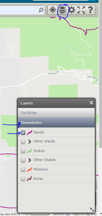
There are three maps programs at LDS.org. Use the Ward Map application for your own ward/branch and stake/District. Use the Meetinghouse Locator for all other units. I have only been able to see the unit boundaries and not the stake boundaries, or mission, or temple boundaries in that program. To see the boundaries of other stakes, missions, temples I've had to use the Classic LDS Maps program.richalger wrote:Am I able to view the Stake and Ward boundaries of other Stakes? Or Mission and Temple boundaries?
For unit leaders, there's also CDOL. I'm not sure as classic LDS Maps is still available. At least, I'm not able to find the link.jdlessley wrote:There are three maps programs at LDS.org. Use the Ward Map application for your own ward/branch and stake/District. Use the Meetinghouse Locator for all other units. I have only been able to see the unit boundaries and not the stake boundaries, or mission, or temple boundaries in that program. To see the boundaries of other stakes, missions, temples I've had to use the Classic LDS Maps program.richalger wrote:Am I able to view the Stake and Ward boundaries of other Stakes? Or Mission and Temple boundaries?
It is still there. In the current maps it is an option under the grid icon in the bottom right corner.russellhltn wrote: For unit leaders, there's also CDOL. I'm not sure as classic LDS Maps is still available. At least, I'm not able to find the link.
What grid icon? I'm logged in using Chrome.jonesrk wrote:It is still there. In the current maps it is an option under the grid icon in the bottom right corner.
Bottom right hand corner just to the right of the help icon.russellhltn wrote:What grid icon? I'm logged in using Chrome.
I can see it in both Chrome and Firefox (haven't checked anything else).russellhltn wrote:What grid icon? I'm logged in using Chrome.jonesrk wrote:It is still there. In the current maps it is an option under the grid icon in the bottom right corner.
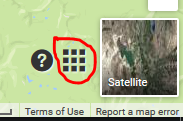
I just checked IE11 and it doesn't show, but if you know it's there you can hover over it and get the tool tip or click on it. Now that's a real easter eggrussellhltn wrote:Ooops. I mis-typed. I'm on IE11 and it's not there. I do see it in Chrome.
I forgot that lds.org is one of the few places I use IE11 on my home machine.
 .
I didn't realize the Classic Maps site was still available. Thanks for the reminder. A lot of things worked really well there, including the boundaries. You can still see some boundaries on the Meetinghouse Locator site, but it's not as nice as the classic maps; you have to click on each unit to see the unit's boundaries.richalger wrote:Will the current maps someday show boundaries like the classic one does?
https://classic.lds.org/maps
If you are not in the Hurst Texas Stake you will need to use the Classic LDS Maps to view the boundaries of the Euless 3rd Ward.tililalilo wrote:Need to view maps for euless 3rd ward boundaries
Where did the hard copy come from? Someone may have misinterpreted the description of the boundaries.rscorse47 wrote:How can we change the boundaries shown on the digital version on LDS.org to match the hard copy ones that the stake has. We lose 6-10 families with the digital edition.
maps.lds.org does indeed show boundaries, but you must be logged in as a member.Gimpy wrote:It doesn't show the boundaries at all. Very disappointed and frustrated.

How does one go about getting a grid icon in the bottom right corner? I don’t have one, and I’d like to view the boundary for the mission that covers where I live. There’s also nothing in the CDOL.jonesrk wrote:It is still there. In the current maps it is an option under the grid icon in the bottom right corner.russellhltn wrote: For unit leaders, there's also CDOL. I'm not sure as classic LDS Maps is still available. At least, I'm not able to find the link.
Good question. I see it even if I'm not logged in, so I don't think it's calling dependent. You might try using Chrome or at least something Chromium-based. I think that engine tends to be more reliable on church sites.TerrySackett wrote:How does one go about getting a grid icon in the bottom right corner?
I beg to differ. I pulled up your stake in CDOL, used "Associated Organizations" to pull up the mission, and found the map in a toolbar-like space on the top.TerrySackett wrote:There’s also nothing in the CDOL.
"New" is based on post count, not join date (which is also shown).TerrySackett wrote:BTW, I was a ward clerk ten years ago and a regular user of this forum, even though I’m being portrayed as a new member.
Okay, thanks. I’m not good enough at separating quotes at this level, so I won’t try.russellhltn wrote:Good question. I see it even if I'm not logged in, so I don't think it's calling dependent. You might try using Chrome or at least something Chromium-based. I think that engine tends to be more reliable on church sites.TerrySackett wrote:How does one go about getting a grid icon in the bottom right corner?
I beg to differ. I pulled up your stake in CDOL, used "Associated Organizations" to pull up the mission, and found the map in a toolbar-like space on the top.TerrySackett wrote:There’s also nothing in the CDOL.
In addition, you might want to check out directory-beta.lds.org which is the next gen directory and map combined.
"New" is based on post count, not join date (which is also shown).TerrySackett wrote:BTW, I was a ward clerk ten years ago and a regular user of this forum, even though I’m being portrayed as a new member.


I can't tell you the number of times I've typed "maps", see the URL complete, and end up at maps.google.com instead of maps.lds.org.TerrySackett wrote:which went to Google Maps.
russellhltn wrote:I can't tell you the number of times I've typed "maps", see the URL complete, and end up at maps.google.com instead of maps.lds.org.TerrySackett wrote:which went to Google Maps.
It's working for me. That suggests your unit may have data problems. I'd use the feedback link to report it.TerrySackett wrote:I’ve tried a few times over the past six days to view the maps beta site, but I just keep getting a message that say “We’re having problems right now. Please try again later.”
Okay, thanks. Knowing my unit as I do, I don’t think anyone will be jumping at the chance to look into it. I submitted an issue to my stake 11 years ago about the address of our building being entered incorrectly and therefore not showing up in Google Maps in the right place. It was never dealt with. Easier that way, I guess.russellhltn wrote:It's working for me. That suggests your unit may have data problems. I'd use the feedback link to report it.

If you will go to the main Church website and select Find a Meetinghouse, you will be able to type in the address and be shown several wards that serve the area, including a Spanish Ward.anamariabernalprice wrote:Moved to [address removed] and would like to know what Spanish ward to go to
To clear up any possible misunderstanding, this is a user-to-user mutual-help forum. Posts here are visible to anyone with or without a Church Account.ppriester wrote:Village road charleston sc
Use your web browser and sign onto churchofjesuschrist.org and go to Ward Directory and Map.dancej wrote:Is there a way to view the ward boundaries on an iPhone?
If you will enter your street address here: https://www.churchofjesuschrist.org/maps/meetinghouses you will see the ward, meeting time, building location, and contact information for the bishop.taylord12 wrote:... South ... W. Rexburg Idaho Hyde park apartments
[Moderator edit: Removed specific parts of street/mailing address.]
The link to the classic maps tool app is correct. The method to navigate to that tool app needs clarification. The "current Church maps site" is the Meetinghouse Locator menu item link or Find a Church menu item link, depending on the menu displayed on the churchofjesuschrist.org site.cierrabrooke wrote:Since the Church migrated domains it's now https://classic.churchofjesuschrist.org/maps. Like the screenshot in the thread, you can navigate here by clicking the little grid of 9 boxes to the right of the help button, in the lower right corner of the current Church maps site.
The post before yours tells you how to access the maps. The stake president would send any recommendations for changes in boundaries to the First Presidency and Quorum of the Twelve, so you would need to discuss any boundary concerns you may have with your stake president.dimondb wrote:I like to view the boundry map of the wards in post falls id i dont think the were devided up fairly
The forum doesn't work that way. You'll have to use the instructions and tips in the thread.todd.peacock wrote:Vernal, Utah 5th ward
Go to the ChurchofJesusChrist.org website, select Meetinghouse Locator, and enter the address there. It will show you the units for that address (Black Hills Ward).susanmowry wrote:What Ward am I in if l live at 1685 N. Cholla Lane, Clarkdale, Arizona
Please remember this is a user-to-user discussion forum, not an official help request channel. If you were to call the temple in question, someone there might be able to direct you to the map. If this is for an official Church purpose, your stake clerk may be able to get the information.joylynnette wrote: Tue Jul 25, 2023 4:13 pm I would like a map showing the new boundaries of the Jordan River temple. Thank you
Gardner ward
Re: Gardner ward
You'll need to use either your Ward Directory and Map to see the boundary if this is your ward. If it is not your ward, then you will need to use the Meetinghouse Locator to see the boundaries.
Your leaders should know and, if they do not, your ward clerk is able to look it up quickly in CDOL, the online Church Directory of Organizations and Leaders.rmrichesjr wrote: Sun Dec 17, 2023 5:39 pm With the no-cost magazine subscriptions being phased in by area, it's important for a member to be able to find what area his/her stake is in. I searched around for a way to find area boundaries or a statement of which area my stake is in--to no avail. Is there a way to find out which area one's stake is in?
If you go to Ward Directory and Map under the nine-dot menu at the top right, it will take you to a map of your ward. If you click on Missionary at the bottom left of the page, the page will display your mission boundary.jdlessley wrote: Wed Nov 22, 2023 3:17 pm Mission boundaries can be found on CDOL. If you do not have the appropriate calling for the necessary access required in CDOL then you will not be able to see the mission boundaries.
And, the upper left-hand corner shows the name of the mission for anyone who might not know that already.lajackson wrote: Sun Dec 17, 2023 6:19 pm If you go to Ward Directory and Map under the nine-dot menu at the top right, it will take you to a map of your ward. If you click on Missionary at the bottom left of the page, the page will display your mission boundary.
The simplest way would simply be to go to MagazineSubscriptions.ChurchofJesusChrist.org and see if you can sign up.rmrichesjr wrote: Sun Dec 17, 2023 5:39 pm With the no-cost magazine subscriptions being phased in by area, it's important for a member to be able to find what area his/her stake is in. I searched around for a way to find area boundaries or a statement of which area my stake is in--to no avail. Is there a way to find out which area one's stake is in?
Go to the Meetinghouse Locator and input the address there to see the unit(s) serving that address.KarllaP wrote: Sun Jan 07, 2024 3:55 pm please help me find my new ward. address 790 Cessna Court, Spring Creek, Nevada 89815
Gadsden alabama
richalger wrote: Fri Mar 03, 2017 8:22 am Where can I view the boundaries of ward, stakes etc in maps.lds.org?
Re: Gadsden alabama
This is a user-to-user discussion forum, not a search engine. The earlier posts in this thread might contain answers to the questions of whether it is possible to see boundaries of your own and/or other wards, stakes, etc.